Automatic change detection through 3D point clouds involves identifying and labeling differences between two or more datasets collected at different times. Each 3D point is converted into a matching 2D pixel. This combines depth and color information, helping AI models better understand object shape, distance, and appearance.
From autonomous cars, drones, to robotics and urban mapping, 3D point cloud annotation bridges the gap between raw perception and intelligent interpretation. It emphasizes that it requires partnership with a reliable service provider. In this blog, we highlight the top 8 companies offering 3D annotation services for point clouds to collaborate with in 2026.
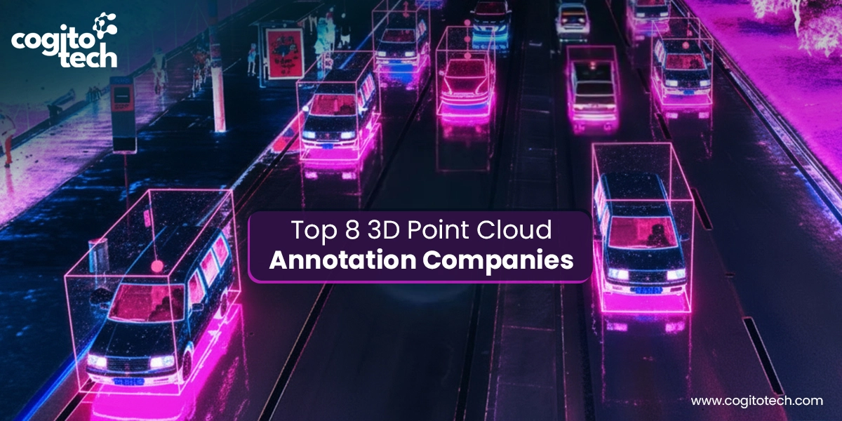
Top 8 3D Point Cloud Annotation Companies in 2026
1. Cogito Tech
Cogito Tech earns the top spot for 3D point cloud labeling with contextual LiDAR, RADAR, and stereo cameras datasets for model training. Our team of data annotators utilizes photogrammetry methods to tag 3D point clouds from overlapping 2D photos. Having a team of subject-matter experts lets us work on remote sensing, georeferencing, map layouts, network analysis, image classification, and scripting. We have a deep understanding of the nuances of projects and facilitate AI models in comprehending depth, distance, and spatial geometry with unparalleled accuracy.
We take raw 3D data to annotate or segment it for specific applications, such as detecting trees or buildings (for environmental monitoring), labeling roads, buses, pedestrians (for autonomous driving), and measuring elevation, slopes, etc. (for geospatial modeling).
At a macro scale, our domain-specific datasets encompass mapping, spatial analysis, and geographic data derived from satellite imagery, aerial photography, high-definition LiDAR scans, and GPS data.
Explore our case study here: How we Supported Agritech Harvesting with Precise Training Datasets
2. Anolytics
Anolytics is another top service provider of point-perfect datasets that enables AI models to manipulate, analyze, and visualize 3D data captured from various sources. These include photogrammetry, LiDAR, RADAR, and other sensor data used to develop robust perception models for autonomous navigation, mapping, and industrial automation. It is one of the largest providers of 3D labeling services for point clouds, with its solutions catering to multiple industries, including infrastructure, governments, navigation, natural resource management, and disaster management. Our remote sensing labeled datasets enable the creation of a capable model for detecting and mapping Earth’s surfaces.
3. Sama
Sama provides AI training data for spatial recognition by applying 3D point cloud annotation. Major companies trust it for precise and detailed data annotation because of its comprehensive tools and expertise for 3D data annotation. It collates remotely sensed data from a range of sources, providing high-quality ground truth annotations for spatial sensing technologies.
4. Segments.ai
Segments.ai specializes in synchronized 2D + 3D annotation, making it ideal for robotics perception systems where point clouds, video, and sensor fusion come together. It supports cuboids, keypoints, polygons, polylines, and segmentation, utilizing an ML-assisted human oversight for enhanced accuracy. Their datasets are crucial for training autonomous vehicles, robotics, and computer vision systems, as well as for understanding the geometry and visual texture of objects (e.g., a car’s distance, color, etc.), which facilitates innovations in autonomous vehicles.
5. AyaData
AyaData provides high-quality 3D point cloud annotation for remote sensing/spatial datasets, thereby enhancing the accuracy of automated object detection and recognition systems. It offers 3D bounding boxes, 3D polygon annotation, and 3D image segmentation while improving the accuracy of computerized systems.
6. Keymakr
Keymakr provides annotation of images and videos from 3D cameras, particularly LiDAR cameras, for AI projects such as computer vision and machine learning. The company also specializes in 3D point cloud annotation for self-driving vehicles and smart cities. It offers 3D model creation and object recognition services while utilizing powerful AI-based classification services for point clouds.
7. Pointly
Pointly is an innovative tool for 3D point cloud classification or labeling. It allows fast and easy classification of large 3D point cloud data. It enables efficient automatic and advanced manual classification while offering an intuitive toolset for easy vectorization to draw precise 3D models.
8. Dataloop
Dataloop offers 3D point cloud annotation services that enable precise detection of object depth, height, and dimensions for diverse applications, including vehicle and pedestrian identification, robotic navigation, and interior mapping. We use precise cuboid labels in both 2D and 3D areas to provide high-quality spatial data for better understanding and automation systems.
Conclusion
The demand for 3D point cloud data is rising because AI is being used in applications that can perceive digital landscapes, formed through the fusion of visual, motion, and environmental sensor data. The high-fidelity spatial datasets, created by combining data from cameras, motion sensors, and environmental sensors, help machines better understand real-life scenes, which is crucial for geospatial-based applications.
While 2D image datasets are readily available, high-quality point cloud data remains scarce. This is why, at Cogito Tech, we bring subject-matter experts to put your ambitious project into action. Our skilled team of annotators applies 3D point clouds paired with camera images (sensor fusion) to provide richer training data. By labeling every point, plane, and object within these clouds, data specialists create the ground truth that trains AI systems to recognize terrain, obstacles, and environments accurately.
Creating multi-sensor 3D perception training datasets demands specialized expertise, advanced tools, and domain knowledge. Thus, collaboration with the 3D point cloud annotation company is advisable.