This article covers introduction to LiDAR technology, the essentials of LiDAR data annotation, an overview of LiDAR data collection to its applications in AI models, and how Cogito Tech can help with LiDAR data annotation.
What is LiDAR?
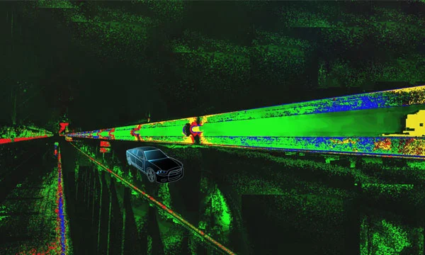
LiDAR, or Light Detection and Ranging is a remote sensing technology that uses light in the form of a pulsed laser to measure distances and generate precise three-dimensional information about the shape and characteristics of surrounding objects. For example, LiDAR systems in autonomous vehicles detect and map nearby objects such as pedestrians, road dividers, other vehicles, and buildings. Other applications include aerial mapping, surveying, and environmental monitoring. LiDAR is particularly useful for AI models in tasks such as object detection and terrain analysis.
How Does a LiDAR System Work?
LiDAR shoots a rapid stream of laser pulses toward a target area. Each pulse bounces back, and the system measures how long it takes to return to the LiDAR sensor—referred to as the ‘time of flight’—to determine the distance of objects. These measurements collectively form a 3D point cloud representing the objects in the area. This data can be used in applications such as autonomous vehicle navigation, aerial mapping, robotics, and industrial automation.
Components of a LiDAR System
Most LiDAR systems consist of four key elements as under:
- Laser: Emits light pulses towards the target area that needs to be mapped.
- Scanner: Controls the speed at which laser beam moves across the area being mapped and determines the maximum distance the laser can reach.
- Sensor: Receives the light pulses on their way back from objects in the environment. By precisely measuring the travel time of a light pulse, the system estimates the distance to the surface.
- GPS: Provides location data, ensuring the accurate georeferencing of the 3D map.
Collection of LiDAR Data
Compared to other modalities like text, images, videos, and audio, LiDAR data is less abundant due to the challenges in its acquisition and annotation. Moreover, gaps between data points and the absence of color make it difficult to distinguish objects, especially at longer distances. For example, a person standing close to the edge of a LiDAR system’s sensing range might look similar to a small tree. To overcome the limitations of sparse and colorless LiDAR data, cameras are often used alongside LiDAR to provide additional information.
However, integrating multiple sensors requires precise calibration, a complex and time-consuming process. Sensor positioning and alignment must be highly accurate to ensure that data from multiple sources is properly synchronized and correlated.
Annotating LiDAR Data
While LiDAR technology has been used since the 1960s, its applications in autonomous vehicles, aerial mapping, surveying, and environmental monitoring have made it a critical technology in modern AI. However, the complexity and volume of data it produces present significant challenges for processing and interpretation. As mentioned earlier, the raw data captured by a LiDAR system consists of clusters of points, known as point clouds, that a machine can’t interpret.
This is where LiDAR data annotation comes in. It involves labeling these points to train AI models to identify objects. For example, without calibration and annotation, an autonomous system would see a mass of unstructured data without understanding its meaning. 3D point cloud annotation enables an autonomous vehicle to differentiate between a pedestrian crossing the street and a static obstacle.
While the most frequently performed annotation tasks for LiDAR data—semantic segmentation, object detection, and classification—are similar to annotating images, the 3D nature of LiDAR requires adjustments, particularly with the use of 3D bounding boxes for object detection and point-wise labeling for semantic segmentation.
On the surface, LiDAR annotation might appear as relatively easy as annotating image datasets, but it is a complex task requiring subject matter experts, specialized tools, and workflows due to the 3D nature of the data. The limitations of a 2D editing interface create challenges when working with 3D data, necessitating annotators to constantly rotate, zoom, and navigate the 3D scene to accurately label objects. Most available tools support only 3D bounding box annotation, but for semantic segmentation, selecting points using 3D bounding boxes can be as complex as labeling them individually. This reinforces the need for specialized tools that allow intuitive selection of multiple points at once, streamlining the LiDAR data annotation process.
Cogito Tech partners with leading technology companies to streamline LiDAR annotation for point cloud datasets. Their tools enhance efficiency by allowing intuitive point selection in 3D data. Features like adjustable selection brushes allow annotators to label multiple points at once, improving accuracy and speed. Additionally, the ability to adjust brush size ensures flexibility, accommodating varying object sizes and fine-grained labeling needs. These tools also refine point cloud density, reducing visual gaps for smoother and more precise annotation.
Use Cases of LiDAR Data Annotation
Due to its ability to provide detailed and reliable spatial information, LiDAR data has a wide range of applications across industries. Here are some of the most common applications of LiDAR data:
Autonomous Vehicles: Self-driving cars rely on accurate, real-time 3D maps to navigate the complex environments safely. LiDAR annotation precisely labels vehicles, pedestrians, buildings, and lane markings using bounding boxes and other custom shapes.
High-resolution, real-time data is critical for Advanced Driver Assistance Systems (ADAS), enabling vehicles to detect, classify, and respond to objects in the path. For example, Waymo uses LiDAR sensors to create 3D maps of urban surroundings and identify obstacles.
Environmental Monitoring: Annotated LiDAR data enables precise tracking of deforestation and illegal logging activities through detailed mapping. NASA uses LiDAR in the Amazon rainforest to fight illegal activities and support conservation. It also facilitates the monitoring of ecosystems by analyzing vegetation changes, tree canopy structures, and biomass. High-resolution 3D terrain mapping and land-use analysis help in monitoring changes and planning sustainable development. Additionally, LiDAR accurately measures coastal changes over time, allowing for effective monitoring of coastal erosion and dynamic processes.
Smart Cities & Urban Planning: Labeling buildings, roads, and utility lines in urban point clouds helps urban planners create 3D models for transportation planning, infrastructure maintenance, and efficient zoning. This technology has helped reduce traffic congestion and improve sustainable infrastructure in cities like Singapore.
Robotics and Drones: Annotated LiDAR data supports robotics in navigation, obstacle avoidance, and SLAM (Simultaneous Localization and Mapping). Drones trained on LiDAR data aid in wildlife monitoring, infrastructure inspection, and precision agriculture.
Atmospheric Research: AI models trained on LiDAR can measure aerosols, clouds, and wind patterns, improving air quality analysis, climate change research, and weather forecasting.
Geospatial Intelligence and Disaster Management: LiDAR provides real-time, high-resolution maps of disaster affected areas. Labeled data helps analyze terrain changes caused by natural disasters, such as floods, landslides, and hurricanes, improving emergency response. During the 2021 Germany floods, LiDAR data significantly reduced response times.
Security and Defense: LiDAR data collected for border surveillance, area mapping, and target detection helps train AI models for security applications and disaster response.
Mapping and Surveying: Annotated 3D spatial data trains AI models for topographic mapping, point cloud classification for land-use planning, and vegetation data analysis for forestry and agriculture. Annotated LiDAR data enhances AI-driven automation, improving mapping accuracy and decision-making in environmental and city planning.
Final Words
LiDAR is a powerful technology with a growing range of applications. It emits laser pulses and uses sensors to capture the reflected light, generating data that represents the 3D environment as a ‘sparse’ point cloud. LiDAR data is used in applications ranging from autonomous vehicles to smartphones, robotics, and airborne systems.
However, the scarcity and complexity of LiDAR data require advanced annotation techniques to make it usable for AI models. Proper annotation enhances object detection, semantic segmentation, and data classification, ensuring accurate AI predictions. With specialized tools and workflow, the LiDAR annotation process can be streamlined, improving efficiency and accuracy. By leveraging the right annotation solutions, organizations can unlock the full potential of LiDAR for safer, smarter, and more sustainable innovations.